Agriculture & Soil
Introduction:
Accurate information on nature, extent and potential of soil resources is essential for optimal utilization of the resource for sustainable development. Study of soil resources at large scale mapping using Satellite Imagery has proved to be quite useful as it reduces time and man power required when compared to gathering information through ground surveys.
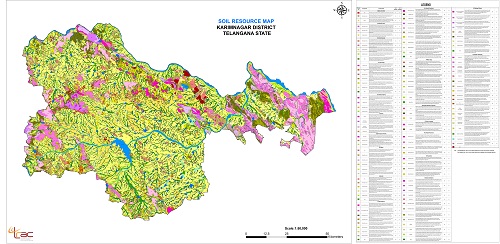
Objectives:- To generate watershed based information on nature, extent and potential of soil resources
- To prepare soil map on 1:10,000 scale using SOI toposheets and satellite remote sensing data using uniform legend.
- To integrate and develop methodology for watershed treatment plan in general and crop specific production systems in particular.
- Methodology of soil resource mapping involves the following steps:
- Step-1:Development of Legend.
- Step-2:Pre-field Interpretation for delineation of soil mapping units by using Lithology,Physiography, Slope and Land Use/Land Cover information and development of pre field legend. Selection of sample sites.
- Step-3:Ground Truth collection including profile studies and collection of soil samples.
- Step-4:Soil sample analysis.
- Step-5:Finalization of classification, Post field Interpretation and Map finalization.
- Formulation of Soil Mapping Unit through Six Level Study as per SLUSI Standards.
- Level-1: Landscape
- Level-2: Physiographic
- Level-3: Slope
- Level-4: Land Use
- Level-5: Association of Soil Series
- Level-6: Soil Phases:Each mapping unit is subdivided based on image character to represent a set of soil characteristics like Soil depth and Surface texture, Erosion, Slope and stoniness with in Soil Series and Associations of Soil Series. Details of soil characteristics and their classes required for establishing Soil Phases are as follows:

Objectives:
- Generation of natural resources database and suitable action plans for land and water resources development on 1:10,000 scale for 102 IWMP watersheds for the year 2012-13.
- Identification of problems and potentials of land and water resources.
Adilabad, Karimnagar, Khammam, Mahabubnagar, Nalgonda and Warangal Districts of Telangana.
Deliverables:- Natural resources database on administrative boundaries, settlements, transport net work , drainage, lithology, structure, hydrogeomorphology, slope & its aspect, soils, land capability, land irrigability, crop suitability , land degradation, land use / land cover.
- Draft action plan for land and water resources development.
- NDVI image analysis output data clearly depicting the pre project vegetation Condition of the watershed.
All the tasks completed and submitted the all deliverable out puts.
Objectives:

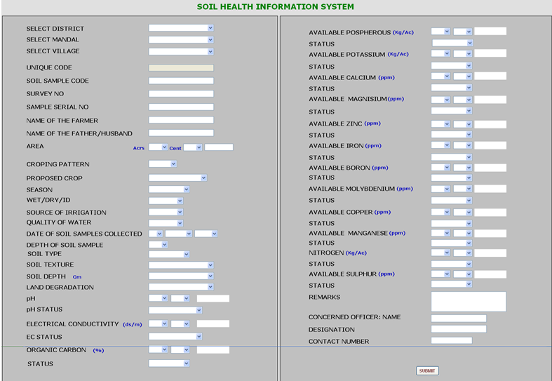
- To organize the available soil analysis data into a data base with geo referencing at cadastral level using GIS Techniques.
- To develop and integrate soil and related thematic data with the database Soil Health Portal.
- To develop Management Information System (MIS) to support different Decision Support Systems (DSS).
- Development of Soil Health Database.
- Development of Soil Health Portal(Web GIS).
- Development of Management Information System (MIS)