Agriculture & Soil
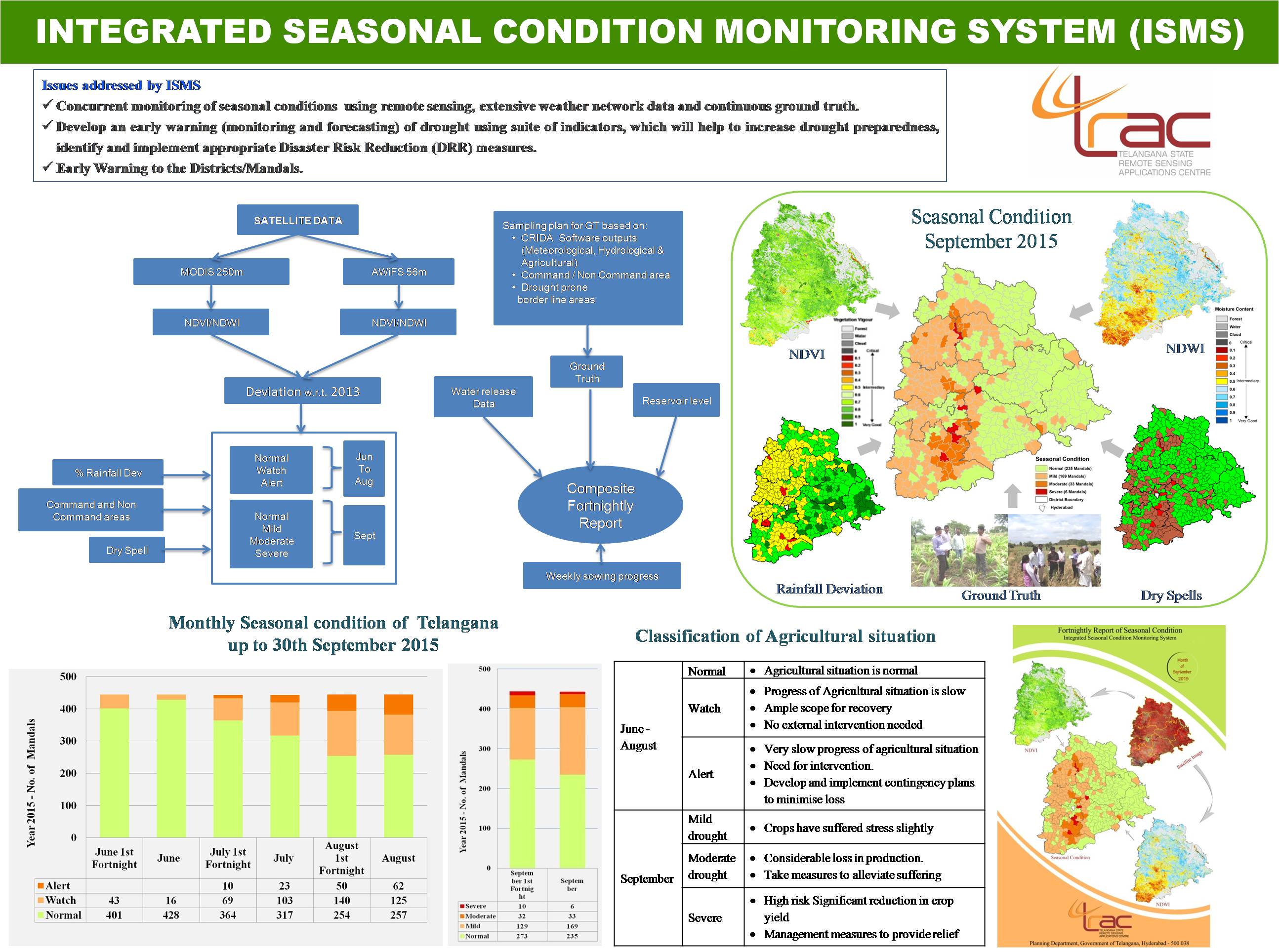
- Concurrent monitoring of seasonal conditions using remote sensing, extensive weather network data and continuous ground truth.
- Develop an early warning (monitoring) of drought using suite of indicators, which will help to increase drought preparedness, and identify and implement appropriate Disaster Risk Reduction (DRR) measures.
- Early Warning to the Districts/Mandals
The study is carried Mandal wise for entire Telangana.
Duration of the Study:June to November (Kharif Season, every year)
Output:Fortnightly report submitted to Commissioner, Disaster Management, Revenue department, Govt. of Telangana.
Data Sets:- MODIS (250m, 16 day composite) and Resourcesat-2 AWiFS data for entire Telangana.
- MODIS Data, ftp://e4ftl01.cr.usgs.gov/molt/ Season And Crop Coverage Report, Kharif - 2013, http://agrisnet.tg.nic.in Water Levels and Water Release Data, http://cadarsms.cgg.gov.in
- Technique development for sugarcane, groundnut, maize, sorghum and cotton crops discrimination, acreage and production forecast using multi-temporal AWiFS and Risat SAR data and validation of rice biomass in selected places.
- Kharif Rice: Acreage estimation of Kharif rice in major Rice growing districts of Telangana for National / State Forecast -NSF
- Kharif Cotton: Acreage estimation of Cotton in major cotton growing districts of Telangana for State/ District forecast- SDF
- Rabi Rice: Acreage estimation of Rabi Rice in districts of Telangana for National State Forecast and State District Forecast-NSF & SDF
Adilabad, Karimnagar, Khammam, Mahabubnagar, Nalgonda and Warangal districts of Telangana.
Duration of the Study:July to April (2015-16)
Data Sets:- Multidate SAR/AWiFS & LISS-III
National Remote Sensing Centre (NRSC), ISRO, Govt of India is executing a national level project, "CHAMAN" (Coordinated programme on Horticulture Assessment and Management using geoiNformatics) in collaboration with Department of Agriculture & Cooperation, Ministry of Agriculture, Government of India with the objective of harnessing the potential of geospatial applications (Remote Sensing, GIS, GPS and ground data) for horticulture development and management planning in selected districts of Telangana. In addition to NRSC, concerned state remote sensing applications centres (SRSAC) and state horticulture departments are actively associated with the execution of the project for detail scientific level studies for developing technology for crop identification, yield modelling and disease assessment.