Projects
Geomatics
TELANGANA DRINKING WATER GRID PROJECT
1. Introduction“Water” is one of the five basic elements of life i.e. air, water, land, fire and sky on the Earth and is the most essential element of life. Even though 3/4th of the Earth’s surface is covered by water, sufficient fresh water is not available both for drinking and irrigation in several parts of the world. India in general and Telangana State in particular are among them. Freshwater problem is not limited to the arid climatic regions, even in areas with good supply the access to safe water is becoming a critical problem. Water on the Earth goes through a gigantic cycle of conversion to gaseous form by evaporation and coming down again to Earth as precipitation. The main source of water is the surface water that flows in streams, rivers and groundwater, which are highly influenced by the physical factors of watershed. Water has been identified as an integral part of the socio economic fabric. It is tagged to the destiny of man. It is reported that 2/3rd of the world does not have safe drinking water and 1/5th of the urban population and 3/4th of the rural inhabitants do not have safe supplies of drinking water.
The Objective of the project is to make the effective utilization of GIS in water grid sector for preliminary plan, situation analysis, updating, storing, monitoring and evaluation of interventions effectiveness that are required for decision making and planning of spatial and non spatial data. The Telangana government has proposed to build a water grid that would meet the drinking water needs of all the towns and villages besides the requirements of the industry in the state.
A total of 126,000-km of water pipeline, including the main trunk line, secondary network and the distribution lines, is proposed to be built as part of the project under which the water will be pumped to places at higher contours at various locations and from there to different places by gravity wherever possible, according to a preliminary plan. The government proposes to divert huge amount of water from Krishna and Godavari basins and about 80 tmc of water was estimated to be required for the needs of the entire state.
3.Objectives- Preparation of Geospatial database of existing rural watersupply infrastructure
- Topographic analysis for planning the supply from selected surface water sources to the feasible habitations by gravity.
- Proximity analysis for optimum and economically routed pipelines by identification of hillocks
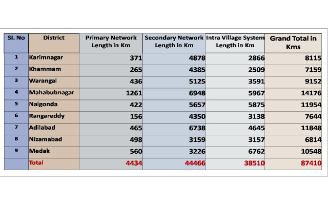
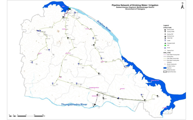
Pipeline Network at a glance