Geosciences
NRSC, Department of Space (DoS), Govt of India & Rajiv Gandhi National Drinking Water Mission (RGNDWM), Ministry of Drinking Water & Sanitation, Govt. of India
Objective:- Creation of seamless mosaic of 17 layers and Hydrogeomorphology maps on 1:50,000 Scale for entire Telangana state as per the guidelines of RGNDWM Phase-III.
Part of Telangana is covered under Phase-I of the project and the remaining part is covered in Phase-III. The guidelines were different for Phase-I to Phase-III. Under the Seamless Mosaic Project, all the maps pertaining to Telangana State generated are brought in to common format as adopted by RGNDWM Phase III i. e. LCC projection with WGS84 datum.
Output:- Grid wise and seamless mosaic of Hydrogeomorphology maps on 1:50,000 Scale for entire Telangana state as per the guidelines of RGNDWM Phase-III.
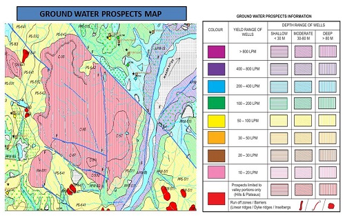
Groundwater is the main source of water for domestic, agriculture and industrial uses. Telangana State Remote Sensing Applications Centre (TRAC) in collaboration with National Remote Sensing Centre (NRSC/DoS) and sponsored by Ministry of Drinking Water & Sanitation, Govt. of India has prepared the Ground Water Prospects maps for the state of Telangana. The maps are prepared scientifically by using satellite remote sensing technology with limited field checks on 1: 50,000 scale. The maps show prospective zones for ground water occurrence and tentative locations for constructing recharge structures. The information provided in the ground water prospects maps form a suitable database for narrowing down the target zones and systematic selection of sites for drilling after conducting follow up ground surveys. This information can be utilized by hydrogeologists, Engineers and other private / NGO organizations for ground water development.
Spatially user can visualizes the Ground Water Prospects information in terms of depth (shallow, moderate and deep) shown with three colour hatching patterns (horizontal, inclined and vertical) and yield shown in seven colours (VIBGYOR - Violet, Indigo, Blue, Green, Yellow, Orange and Red) with simplified legend.
Output of the Project: Under the NGLM project following colour thematic map outputs are delivered on 1:50,000 scale in the soft copy of pdf / jpeg format and Geodatabase of Telangana mosaic.
- Geomorphology (Geodatabase)
- Lineament (Geodatabase)
- Field Data (Geodatabase)
Data Utility:
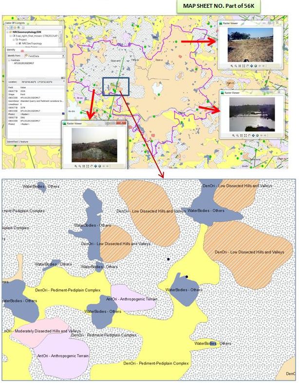
The project is first of its kind at national level for large scale mapping on Geomorphological & Lineament Mapping on 1:50,000 scale taken up under National (Natural) Resources Census (NRC). This is essentially more generic and covers the applied geological problems like mineral exploration, geo-hazards, geotechnical and geo-environment unlike the earlier maps prepared under NRIS and RGNDW missions which were essentially for ground water applications.
TRAC is the nodal agency for Remote Sensing, GIS and related applications, registered under AP societies Registration Act, 2001 (779 of 2009) with Telangana Adaptation Order 2014. As per G. O. Ms. No. 28 & 29, Planning (I) Department, Dt. 05-08-2013, orders have been issued for establishment of Telangana (erstwhile Andhra Pradesh) Geo-graphic Management Information System (TSGMIS) & Telangana (erstwhile Andhra Pradesh) State Spatial Data Infrastructure (TSSDI). The TSGMIS is established with an objective of a new information regime supporting good governance, sustainable development and citizen empowerment through offering GIS decision support services; a state-wide, standardised, seamless and most-current GIS asset for governance, private enterprise and citizens. The TSSDI as state level repository of a digital “warehouse” of the state map data holdings (that include the satellite images, SoI maps and other GIS layers) and to facilitate the sharing and access of the digital spatial information for promoting remote sensing based planning and monitoring of activities at community, local and state levels for better governance.
As part of TSSDI & TSGMIS, Spatial Data Management Hub (SDMH) will be established in 14 selected departments and RWS&S is one of the departments identified. The Geosciences Division of TRAC has conducted half-a-day training programme to about 352 Engineers in 9 batches on "Fundamentals of Remote Sensing (RS) & GIS Application and usage of Ground water prospecting" during October 2013 to April 2014 as part of induction training programme to newly recruited RWS&S Engineers. The SDMH shall have the overall goal to improve the quality of life by enhancing access to better water supply & sanitation facilities in the rural areas and ensuring sustainability.
The remote sensing and GIS techniques have emerged as very effective and reliable tools in the groundwater studies. The Spatial Data Management Hub (SDMH) in RWS&S helps in sustainably managing the community based water supply schemes. GIS helps in monitoring the status of habitations, for selecting site specific locations for studying regional water quality monitoring, to know up to date status of the water quality affected habitations and to alert the administration / local community for taking alternate remedial measures.
Training content:- Concepts of SDMH & RWSS Functions
- Principles of Remote Sensing & GIS
- Preparation and Usage of Groundwater Prospects Maps
Engineering Staff College of India (ESCI) & TSIPARD(Telangana State Institute Of Panchayat Raj And Rural Development(erstwhile APARD) Hyderabad